1/5

High Precision Dual Frequency Gnss Rtk GPS System/Land Surveying Intrument
$0.10 / Set
- FOB Price:
- Negotiable | Get Latest Price
- Order Quantity:
- 1 Set / Sets
- Supply Ability:
- 1000 Set / Sets per Month
- Port:
- shanghai
- Payment Terms:
- T/T L/C D/P D/A Credit Card PayPal Cash Escrow Other
- Delivery Detail:
- 5 days
Hot in store
-
Borehole Geophone Land Geophones Seismi
$1.00 -
Geophysical Well Logs Aquifer Mapping We
$1.00 -
Masw/Refraction/Reflection/Borehole Surv
$1.00 -
Geophone Sensors Mems Geophone Geophone
Inquiry -
Digital Incinometer Borehole Inclinomet
$1.00 -
Borehole Deviation Tester Wireless Incl
$1.00 -
Jqx-2 Best Selling Digital Inclinometer
$1.00 -
Portable Digital Inclinometer for Drilli
$1.00
Product Details
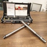
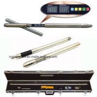
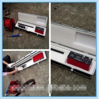
Product Name: High Precision Dual Frequency Gnss Rtk GPS System/Land Surveying Intrument Model NO.: V60 GNSS RTK GPS Horizontal Line: 2 Vertical Lines: 2 Accuracy: 2mm Condition: New Screen Size: 3.7inch Operation System: Linux Operation System Satellite Support: Glonass,GPS,Sbas Channle: 220 Horizontal Accuracy(Static): 2.5mm+0.5ppm Vertical Accuracy(Static): 5mm+0.5ppm Main Application: Surveying and Mapping Weight: 1.25kg Water/Dustproof: IP67 Trademark: Hi-Target Transport Package: Natural Package Specification: CE, FCC Origin: Chongqing HS Code: 9015800090 Product Description High Precision Dual Frequency Gnss Rtk GPS System/Land Surveying IntrumentThis kind of GNSS RTK GPS is widely used in surveying and mapping in engineering construction and geological.For it's advantages of the good qualilty,competitive price,high precision,light weight...,it's popular in the market.The V60 GNSS RTK GPS is a more compact-design and higher-performance GNSS RTK system, besides its rugged design to resist impact and vibration. The V60 has industrial OLED display screen on its front control panel to show all information and status of the work. With the smart speaker inside the receiver, the DIY guiding voice can be customized in any language, even dialect! 1GB internal storage plus 8GB Micro SD card memory is standard, the V60 supports up to 32GB extension of memory. The V60 is fully compatible with other GNSS RTK receivers from the world market. The static data can be saved directly in RINEX format.Specification of V60 GNSS RTK GPS:Measurements220channelsAdvancedPacificCrestMaxwell6CustomSurveyGNSSTechnologyHighprecisionmulciplecorrelatorforGNSSpesudorangeUnfiltered,lownoice,lowmultipatherror,lowtimedominecorrelationVerylownoiseGNSScarrierphasemeasurementswith<1mmprecision(1Hz)Signal-to-NoiseratioreprtedindB-HaProvenPacificCrestlowelevationtravkingtechnologySatelliteSingnalsTracked GPS:L1C/A,L2C,L2E,L5SimultaneouslyGLONASS:L1C/A,L1P,L2C/A(GLONASSMonly),l2pSBAS:L1C/A,L5Galileo:L1BOC,E5A,E5B,E5ALtBOCBDS/Compass:B1,B2QZSS:L1C/A,L1SAIF,L2C,L5PositioningperformanceStaticandFastStaticHorizonta:l2.5mm+0.5ppmRMSGNSSsurveyingVertica:l5mm+0.5ppmRMSPostProcessingKinematicHorizontal:1cm+1ppmRMS(PPK/Stop&Go)GNSSsurveyingVertical:2.5cm+1ppmRMSInitializationtime:typically10minutesForbasewhile5minutesforroverInitializationreliability:typically>99.9%RealtimeKinematic(RTK)surveyingHorizontal.8mm+1ppmRMSVertical.15mm+1ppmRMSInitializationtimetypically<8secondsInitializationreliability.typically>99.9%CodeDifferentialGNSSpostioningHorizontal.25cm+1ppmRMSVertical.50cm+1ppmRMSSABS:0.50mHorizontal,0.85mVerticalHardwarePhysicalDimensions(W×H):18.20cm×9.80cm(7.17in.×3.86in.)Weight:1.25kgs(2.76lbs)withoutinternalbatteryOperating:-45°Cto+65°C(-49°Fto+149°F)Storagetemperature.-55°Cto+85°C(-67°Fto+185°F)Humidity:100%,consideringWater/dustproof.IP67dustproof,protectedfromTemporaryimmersiontodepthof1m(3.28ft)ShockandVibration.Designedtosurvivea3m(9.84ft)naturefallontocontrete.ElectricalPower6Vto28VDCexternalpowerinputPowerconsumption≤3.5wAutomaticSwitchingbetweeninternalpowerandexternalpowerRechargeable,removable7.4V,5000mAhLithium-IonBatteryininternalbatterycompartmentInternalbatterylifeStatic13-15hoursRTKRover(UHF/GPRS/3G)10-12hoursRTKbase8-10hoursI/Ointerface1×Bluetooth1×standardUSB2.0port1×TNCUHFconnector2×RS232serialport2×DCpowerinput(8-pin&5-pin)1×MicroSDcardportCommunicationanddatastorage3GCommunicationFullyintegrated,fullysealedinternal3G,compatabilewithGPRSNetworkRTK(viaCORS)range20-50kmHI-TRAGERTinternal UHFradio(standard)Frequency:450~470MHzwith116channelTransmittingPower:1W,2W,5W,adjustableTransmittingSpeed:9.6Kbps,19.2KbpsWorkingRange:5kmtypical,8-10kmoptimalPacticicCrestXDLMicrointernalUHFRADIOFrequency:403-473MHzTransmittingPower:0.5W,2WadjustableTransmittingSpeed:Upto19.2KbpsWorkingRange:3-5kmtypical,8-10kmoptimalHi-TargetexternalUHFradio(standard)Frequency:460MHzwith116channelsTransmittingPower:5W,10W,20W,30WadjustableTransmittingSpeed:Upto19.2KbpsWorkingRange:8-10kmtypical,15-20kmoptimalPacificCrestADLvantageProExternalUHFradioFrequency:390-430MHzor430-470MHzTransmittingPower:4Wto35WadjustableTransmittingSpeed:Upto19.2KbpsWorkingRange:8-10kmtypical,15-20kmoptimalSupportotherexternalCommunicationdeviceForexample,externalGSMmoderm.DataformatsCMR:sCMRx,CMR,CMR+inputandoutputRTCM:RTCM2.12.22.33.03.13.2inputandoutputNavigationoutputsASCII:NMEA-0183NavigationoutputsBinary:GSOF1PulesPerSecondOutputMain Features of the V60 Dual Frequency GNSS RTK GPS:Linux Operation SystemARM 9G20 400MHz CPU, embedded Linux OS to support faster data transmission.Intelligent Operation1). Equipped with smart speaker guiding during the whole operation. Voice assistance can help you master V60 operation quickly. Language can be customized.2). Industrial LED display screen on its front control panel to show all information and status of the work.3). Many one-button operations make your work easily. base setup by one button can choose base coordinate from base list automatically.4). Automatic recording system log makes receiver diagnosis easy.RINEX StorageThestaticdatacan be saved directlyin RINEX format.TheV60 is fully compatible with other brands' receivers.Quick UpgradeJust copy the updated firmware to the V60, then restart to finish the upgrade in a few seconds.Multi Constellation Tracking1). 220 tracking channels.2). Supports GPS, GLONASS, GALILEO, BDS, SBAS.3). Built-in NGS Approved Antenna.High Power Transceiver UHF Radio1).The transceiver UHF radio enables the working mode switchable between base and rover.2). 5 watts (Max.) HI-TARGET internal UHF radio and 2 watts (Max.)Pacific Crest micro XDL internal UHF radio are optional3). Pacific CrestTrimTalk© internal UHF radio is compatible with other RTK.Seamlessly Operation in CORS SystemBuilt-in GPRS/GSM/3G module makes V60 work perfectly with network RTK positioning.Long-life Battery1). Powered by 5000mAh Li-Ion battery.2). Static working time 13 - 15 hours3). RTK Rover(UHF/GPRS/3G) working time 10 - 12 hours4). RTK base working time 8 - 10 hoursRugged Design, IP671). IP67 dust/water protection.2). Withstands 3 meters natural fall onto concrete.3). Rapidly track and perfectly avoid or lessen obstruction and multipath effect to ensure superior positioning capability.Contact US:
Contact with Supplier
Recommend product
-

Stripped Soft Goose Fe
$3.00 -
plastic ball grinding
$30000.00 -
CAT piston pump 281
$4000.00 -

Droichead Zirconia Plu
$10.00 -

E.max crown, Veneer, I
Inquiry -
ReSiC Beams/plates/bur
$16.00 -
RSiC Slabs Boards Tile
$15.00 -
RSiC Batts as Kiln she
$15.00 -

RSiC Tube by recrystal
$10.00 -
RSiC Kiln Furniture (B
$16.00 -
RSiC Burner Nozzle Fla
$18.00 -
RSiC Beam Support Pill
$16.00 -
RSiC plate Slab Board
$15.00 -

NSiC Tube Pipes by Nit
Inquiry -

used excavator hudraul
$16600.00 -
NSiC Thermocouple Prot
Inquiry -

Stalk Riser Tube for L
Inquiry -

NSiC Ceramic Heater Pr
Inquiry -

RSiC NSiC Ceramic Kiln
Inquiry -

used excavator hudraul
$11500.00
Product parameters
closure
This shop is operated by agent
- Set up shop
- Authorized by Manufacturers & Suppliers online marketplace B2B platform GongWong.com, can provide agency service
- Service Introduction
- Authorized product, Internet cloud promotion service integrating certification promotion and procurement inquiry
- Intelligent website construction
- PC terminal + mobile terminal, create a cost-effective corporate website!
closure