1/5

Geodetic GPS Receiver for Land Surveying GPS Gnss Rover Base with UHF Radio
$0.10 / Set
- FOB Price:
- Negotiable | Get Latest Price
- Order Quantity:
- 1 Set / Sets
- Supply Ability:
- 1000 Set / Sets per Month
- Port:
- shanghai
- Payment Terms:
- T/T L/C D/P D/A Credit Card PayPal Cash Escrow Other
- Delivery Detail:
- 5 days
Hot in store
-
Borehole Geophone Land Geophones Seismi
$1.00 -
Geophysical Well Logs Aquifer Mapping We
$1.00 -
Masw/Refraction/Reflection/Borehole Surv
$1.00 -
Geophone Sensors Mems Geophone Geophone
Inquiry -
Digital Incinometer Borehole Inclinomet
$1.00 -
Borehole Deviation Tester Wireless Incl
$1.00 -
Jqx-2 Best Selling Digital Inclinometer
$1.00 -
Portable Digital Inclinometer for Drilli
$1.00
Product Details
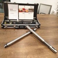
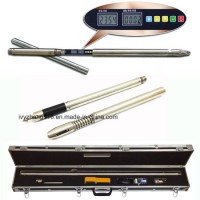
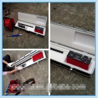
Product Name: Geodetic GPS Receiver for Land Surveying GPS Gnss Rover base with UHF Radio Model NO.: V60 GNSS RTK System Certification: ISO2000, ISO14001, ISO/TS16949 Chip: MStar Port Number: Multiplex Multi-purpose Channel Carrier Frequency: Dual-Frequency Type: GPS Navigator Operating Principle: Mixed Type Gnss Solutions: Gnss Antenna Surveying and Construction: Mapping and Gis Environment Studies: Geomarking Archaeology: Accident Reconstruction as-Built Surveys: Topographic Surveys Right-of-Way Surveys: Tentative Maps Electrical Distribution: Traffic Control Planning Traffic Signal Design: GPS Navigator GPS Navigation: Gnss Antenna Gnss Receive: Data Collector Use: Automotive&Hand Held Model: Total Station Type Screen Size: 2.5" Brand: Hi-Target Trademark: Hi-Target Transport Package: Cartonbox Origin: Chongqing HS Code: 9002209000 Product Description Geodetic GPS Receiver for Land surveying GPS GNSS UHF RadioV60 GNSS RTK SYSTEMThe V60 is a more compact-design and higher-performance GNSS RTK system, besides its rugged design to resist impact and vibration. The V60 has industrial OLED display screen on its front control panel to show all information and status of the work. With the smart speaker inside the receiver, the DIY guiding voice can be customized in any language, even dialect! 1GB internal storage plus 8GB Micro SD card memory is standard, the V60 supports up to 32GB extension of memory. The V60 is fully compatible with other GNSS RTK receivers from the world market. The static data can be saved directly in RINEX format.TechnicalParametersMeasurements220trackingchannelsAdvancedPacificCrestMaxwell6CustomSurveyGNSSTechnologyHighprecisionmultiplecorrelatorforGNSSpseudorangemeasurementsUnfiltered,unsmoothedpseudorangemeasurementsdataforlownoise,lowmultipatherror,lowtimedomaincorrelationandhighdynamicresponseVerylownoiseGNSScarrierphasemeasurementswith<1mmprecisionina1HzbandwidthSignal-to-NoiseratiosreportedindB-HzProvenPacificCrestlowelevationtrackingtechnologySatellitesignalstrackedsimultaneouslyGPS:SimultaneousL1C/A,L2C,L2E,L5GLONASS:SimultaneousL1C/A,L1P,L2C/A(GLONASSMonly),L2PSBAS:SimultaneousL1C/A,L5Galileo:SimultaneousL1BOC,E5A,E5B,E5AltBOCBDS:B1,B2QZSS:L1C/A,L1SAIF,L2C,L5PositioningAccuracyStaticandFastStaticGNSSsurveyingHorizontal:2.5mm+0.5ppmRMSVertical:5mm+0.5ppmRMSStop&GoGNSSsurveyingHorizontal:1cm+1ppmRMSVertical:2.5cm+1ppmRMSInitializationtime:typically10minutesforbasewhile5minutesforroverInitializationreliability:typically>99.9%RealtimeKinematic(RTK)surveyingHorizontal:8mm+1ppmRMSVertical:15mm+1ppmRMSInitializationtime:typically<8secondsInitializationreliability:typically>99.9%CodeDifferentialGNSSpositioningHorizontal:25cm+1ppmRMSVertical:50cm+1ppmRMSSBAS[iv]:0.50mHorizontal,0.85mVerticalHardwarePhysical1.Dimensions(WxH):19.50cmx10.40cm(7.68inx4.09in)2.Weight:1.3kg(2.86lb)withinternalbattery,internalradio,standardUHFantenna3.Operatingtemperature:-45ºCto+65ºC(-49ºFto+149ºF)4.Storagetemperature:-55ºCto+85ºC(-67ºFto+185ºF)5.Humidity:100%,considering6.Water/dustproof:IP67dustproof,protectedfromtemporary7.immersiontodepthof1m(3.28ft).8.ShockandVibration:Designedtosurvivea3m(9.84ft)naturalfallontoconcrete.9.Storage:64MElectrical1.Power6Vto28VDCexternalpowerinput2.Powerconsumption2.5W3.AutomaticSwitchingbetweeninternalpowerandexternalpower4.Rechargeable,removable7.4V,5000mAhLithium-Ionbatteryininternalbatterycompartment5.Internalbatterylife,Static13-15hours,RTKRover(UHF/GPRS/3G)10-12hoursandRTKbase8-10hoursCommunicationGPRS/GSMor3GFullyintegrated,fullysealedinternalGPRS/GSMor3GNetworkRTK(viaCORS)range20-50kmHI-TARGETinternalUHFradio(standard)Frequency:460MHzwith116channelsTransmittingPower:0.1W,1W,2WadjustableTransmittingSpeed:Upto19.2KbpsWorkingRange:3~5Kmtypical,8~10kmoptimalPacificCrestXDLmicroInternalUHFRadio(Optional)Frequency:403~473MHzTransmittingPower:0.5W,1.0W,2.0WadjustableTransmittingSpeed:Upto19.2KbpsSupportmostofradiocommunicationprotocolWorkingRange:3~5kmtypical,8~10kmoptimalHI-TARGETExternalUHFradio(standard)Frequency:460MHzwith116channelsTransmittingPower:5W,10W,20W,30WadjustableTransmittingSpeed:Upto19.2KbpsWorkingRange:8~10Kmtypical,15~20kmoptimalPacificCrestADLVantageProExternalUHFradio(Optional)Frequency:390~430MHzor430~470MHzTransmittingPower:4Wto35WadjustableTransmittingSpeed:Upto19.2KbpsSupportmostofradiocommunicationprotocolWorkingRange:8~10Kmtypical,15~20kmoptimalWarranty: 12 months warranty is offered for survey equipment. 6 months warranty offered for survey accessory. Warranty comes in effective from the day your receive good2. Repair in warranty: We are responsible for supplying new parts for repairing. Round way freight will be bored by us. If it is necessary, product will be required to send back to our service center to be repaired, round way freight is charged by us. Our engineer will repair in your office for special case3. Repair out of warranty: We will offer related parts at commercial cost. Freight will be shared by us4. Training and calibration: Our engineer is qualified for training and calibration for GNSS and Total Station on site. We offer this service to bulk order while customer has requirement5. Technical support is offered 24/365
Contact with Supplier
Recommend product
-
Stripped Soft Goose Fe
$3.00 -
plastic ball grinding
$30000.00 -
CAT piston pump 281
$4000.00 -

Droichead Zirconia Plu
$10.00 -

E.max crown, Veneer, I
Inquiry -
ReSiC Beams/plates/bur
$16.00 -
RSiC Slabs Boards Tile
$15.00 -
RSiC Batts as Kiln she
$15.00 -

RSiC Tube by recrystal
$10.00 -
RSiC Kiln Furniture (B
$16.00 -
RSiC Burner Nozzle Fla
$18.00 -
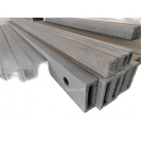
RSiC Beam Support Pill
$16.00 -
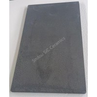
RSiC plate Slab Board
$15.00 -

NSiC Tube Pipes by Nit
Inquiry -
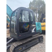
used excavator hudraul
$16600.00 -
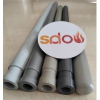
NSiC Thermocouple Prot
Inquiry -

Stalk Riser Tube for L
Inquiry -
NSiC Ceramic Heater Pr
Inquiry -

RSiC NSiC Ceramic Kiln
Inquiry -

used excavator hudraul
$11500.00
Product parameters
closure
This shop is operated by agent
- Set up shop
- Authorized by Manufacturers & Suppliers online marketplace B2B platform GongWong.com, can provide agency service
- Service Introduction
- Authorized product, Internet cloud promotion service integrating certification promotion and procurement inquiry
- Intelligent website construction
- PC terminal + mobile terminal, create a cost-effective corporate website!
closure